
|
 Forums at EliYah's Home Page Forums at EliYah's Home Page
 Scripture Discussion Forum Scripture Discussion Forum
 The True Red Sea Crossing The True Red Sea Crossing
|
 UBBFriend: Email This Page to Someone! UBBFriend: Email This Page to Someone! |
next newest topic | next oldest topic |
| Author | Topic: The True Red Sea Crossing |
|
gmoore44 Posts: 245 |
  
quote: AND. . . .
quote: Shalom William, As per your request, I have started a new thread regarding this issue of the true Red Sea crossing. Well, your view that the crossing took place in the "sea of reeds" is a common view--similar to the view that the crossing took place at the upper end of the Gulf of Suez. While it is true that the word used for "Red Sea" might possibly be translated "sea of reeds", it's contextual usage throughout Scripture shows that it is clearly speaking of the actual "Red Sea" as it is called today--not the "Sea of Reeds." "And I will set thy bounds from the Red sea even unto the sea of the Philistines, and from the desert unto the river: for I will deliver the inhabitants of the land into your hand; and thou shalt drive them out before thee." (Exodus 23:31) Did Israel EVER establish one of it's boundaries at the "Sea of Reeds?" "And king Solomon made a navy of ships in Eziongeber, which is beside Eloth, on the shore of the Red sea, in the land of Edom. And Hiram sent in the navy his servants, shipmen that had knowledge of the sea, with the servants of Solomon. And they came to Ophir, and fetched from thence gold, four hundred and twenty talents, and brought it to king Solomon." (1 Kings 9:26-28) Did king Solomon EVER place naval ships on the "Sea of Reeds" and then send them FROM THERE to the land of Ophir to bring 420 talents of Gold to king Solomon? I think this could not be. If this is really where the children of Israel "crossed over" where are the mountains that supposedly pinned them in? There are NO MOUNTAINS adjacent to the "Sea of Reeds!" And if the so-called "Mount Sinai" is the "true" mountain of Yahweh, then where at its summit is the necessary room for 1-3 million Israelites to camp? The map I linked to earlier was just one of the maps, but it is not a true depiction of what happened at the Exodus. Here is another map, which shows what actually happened:

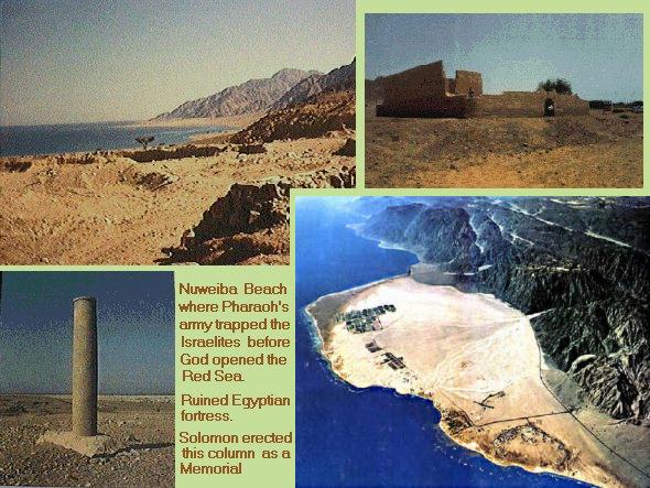
Here below is an other photo, this time of one of the chariot wheels from the armies of Pharoah. It was found at the bottom of the Red Sea near the Gulf of Aquaba near Nuweiba. The wood has mostly rotted away, leaving only the Gold that it was covered by:
Since the issue also concerns chronology, it is interesting to note that during various Egyptian dynasties the types of chariot wheels created had their own special styles. At the bottom of the Red Sea, separately Jonathan Gray and Ron Wyatt discovered 4 spoke, 6 spoke, and 8 spoke chariot wheels. Now 4 and 6 spoked wheels are not that unusual--they can be found in many different dynasties. But the 8 spoked wheel is very unique! It was only made during a brief period in the 18th dynasty of Egypt. That would be in about the middle of the 15th century BCE (somewhere around 1450 BCE). (Please see Observations on the Evolving Chariot Wheel in the 18th Dynasty, James K. Hoffmeier. JARCE, #13, 1976).
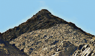
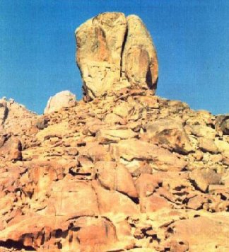
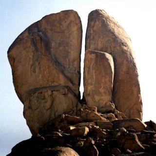
If they were at the "Sea of Reeds" then why did the Egyptians have to ask where they went? If they were supposed to be "weary from their journey", how could that be so if it were only about 10 to 20 miles over 2 days? And if they were pinned in by the Mountains and the Sea, then what mountains are there near the Sea of Reeds which can even come close to qualifying? Now regarding Mount Sinai, if the current "Mount Sinai" is not the real one, then where is the REAL "Mount Sinai?" Well, it is in Saudia Arabia at a place called "Jabel-El Lawz" which in Arabic means "the Mountain of the Law". Ring a bell? In addition to this, Shaul tells us plainly where Mount Sinai is: "For this Agar is mount Sinai in Arabia, and answereth to Jerusalem which now is, and is in bondage with her children." (Galatians 4:25) There are photographs of the rock at Rephidim, the one which Moses struck to bring water to over a million Israelites. This rock is only a short journey away from Jabel-el-Lawz in Saudia Arabia. It is split into 4 parts down from the top to the bottom, with clear evidence of a great amount of water erosion at the base of it, with erosion marks extending out to the valley below. Hope this helps. Best Regards, Glenn PS: Here is a link to only one of the websites which explain the Red Sea Crossing. http://www.biblebelievers.org.au/bb971126.htm If you wish to find other references, please do a search for "True Red Sea Crossing", or "Jonathan Gray" or "Ron Wyatt". ------------------ [This message has been edited by gmoore44 (edited 09-03-2006).] |
|
wstruse Posts: 154 |
Glenn, Here is my previous post from the other thread. Thanks for the links. I believe that the Red Sea crossing took place at the �sea of reeds� as it is called in Exodus 10:19. This would require only a journey of 10-20 miles. Exodus 13:18 18 But God led the people about, through the way of the wilderness of the Red sea: and the children of Israel went up harnessed out of the land of Egypt. ______________________________________ 3220 Sea = {yawm}
After leaving Rameses the Scripture states they encamped before Pihahiroth, between Migdo and the sea. This encampment was just before the crossing of the �see of reeds�. Both Pihahiroth and Migdo are know sites on the Gulf of Suez. The narrative of the Scripture leaves no room for a 160 � 180 mile journey from that encampment before they cross over the �see of reeds�.
After crossing the �sea of reeds� they entered the wilderness of Shur. They then went 3 days into the wilderness. They came to the waters of Marah. From there they went to Elim. After Elim they came into the wilderness of Sin. This is between Elim and Sinai. Some of these sights have been found along the Gulf of Suez. It just seems highly unlikely to me that they crossed over the Red Sea and then travel back around the Gulf of Akubah to Marah, Elim on the other side of the wilderness of Shur.
William Struse
Also note that your maps above do not take into account the Red Sea as it was in the BC era. The Red Sea came all the way up past your current Exodus route. This would have required 2 Red Sea crossings. I will be updating this topic in the future @ www.countdowntothemessiah.com [This message has been edited by wstruse (edited 06-16-2008).] |
|
gmoore44 Posts: 245 |
quote: Shalom William, This is actually my first response, which I am reposting here. Looked over your first post (in the other forum). I noticed that you have made some statements concerning the "timing" of the original Exodus which leaves me baffled. You say that the text shows that "it does not appear that the journey from Succoth to the Red Sea took more than the 15th and 16th." What? How could they travel over 160 [possibly 200] miles in 2 days? Now I have a map of the misnamed "Sinai Peninsula" and it shows that the distance from Succoth to Nuweiba is about 160-180 miles accross the entire peninsula. Nuweiba is (of course) the site of the true Red Sea crossing (See this website map link: http://www.specialtyinterests.net/map_sinai.html). Now maybe I don't have the exact distance, but I am sure it is close to that. I lost my keys recently and had to travel 21 miles, 14 of them by foot. It took me about 9 hours and I thought I was going to die! I cannot imagine the Israelites traveling more than 20-25 miles per day by foot--even if they traveled day and night. I think it would have taken at least 6 days, possibly 8 days to travel to the Red Sea. {http://www.bibleexplained.com/Gospels/map-egypt-sinai.html} Many people believe that Moses and the children of Israel crossed over very close to Succoth near the Gulf of Suez or even at the "Sea of Reeds". If that were true, then yes a 2 day journey would be no problem. However, the evidence from Scripture and a basic understanding of the layout of the land seems to rule out such views. The Israelites crossed over on the other arm of the Red Sea, at the Gulf of Aquaba. (Please see this link for more info: http://www.biblebelievers.org.au/bb971126.htm Regards, Glenn |
|
wstruse Posts: 154 |
Glenn, Regarding the Scriptural usage of the term �Reed Sea� it seems to me that this applied to both peninsulas of the Red Sea proper. Here are the usages of �Red Sea� or �Reed Sea� as given in the Scripture. Exod. 10:19; 13:18; 15:4, 22; 23:31; Num. 14:25; 21:4; 33:10f; Deut. 1:40; 2:1; 11:4; Jos. 2:10; 4:23; 24:6; Jdg. 11:16; 1 Ki. 9:26; Neh. 9:9; Ps. 106:7, 9, 22; 136:13, 15; Jer. 49:21
Deuteronomy 1:1-2 _________________________________________________________________ The wilderness of Shur is defined by the verses below. It is clearly the wilderness Directly south of Israel between Mt Sier and Egypt. Israel went 3 days journey into the wilderness of Shur just after they crossed over the �Red Sea�. The Scripture clearly defines this Shur and secular sources clearly define this area as well. Both are in agreement. There is no way I can see based on just the definition of the Scripture how the wilderness of Shur could be on the other side of the Gulf of Akubah. Below you can see Shur clearly defined on the map link you originally provided me. 1 Samuel 15:7 And Saul smote the Amalekites from Havilah until thou comest to Shur, that is over against Egypt. 1 Samuel 27:8 And David and his men went up, and invaded the Geshurites, and the Gezrites, and the Amalekites: for those nations were of old the inhabitants of the land, as thou goest to Shur, even unto the land of Egypt. Genesis 25:18 8 And they dwelt from Havilah unto Shur, that is before Egypt, as thou goest toward Assyria: and he died in the presence of all his brethren. Genesis 20:1 V Genesis 20:1 And Abraham journeyed from thence toward the south country, and dwelled between Kadesh and Shur, and sojourned in Gerar. Genesis 16:7 And the angel of the LORD found her by a fountain of water in the wilderness, by the fountain in the way to Shur. Exodus 15:22-23 So Moses brought Israel from the Red sea, and they went out into the wilderness of Shur; and they went three days in the wilderness, and found no water. 23 And when they came to Marah, they could not drink of the waters of Marah, for they were bitter: therefore the name of it was called Marah. Faussets Bible Dictionary ISBE Bible Dictionary Brugsch, however, proposed to regard Shur ("the wall") as equivalent to the Egyptian anbu ("wall"), the name of a fortification of some kind apparently near Kantarah (see MIGDOL (2)), probably barring the entrance to Egypt on the road from Pelusium to Zoan. The extent of this "wall" is unknown, but Brugsch connects it with the wall mentioned by Diodorus Siculus (i.4) who wrote about 8 BC, and who attributed it to Sesostris (probably Rameses II) who defended "the east side of Egypt against the irruptions of the Syrians and Arabians, by a wall drawn from Pelusium through the deserts as far as to Heliopolis, for a space of 1,500 furlongs." Heliopolis lies 90 miles (not 188) Southwest of Pelusium: this wall, if it existed at all, would have run on the edge of the desert which extends North of Wady Tumeilat from Kantarah to Tell el-Kebir; but this line, on the borders of Goshen, is evidently much too far West to have any connection with the desert of Shur East of the Gulf of Suez. See Budge, Hist. Egypt, 90; Brugsch, Egypt under the Pharaohs, abridged edition, 320. |
|
Yahwehwitnesses Posts: 2247 |
More maps http://www.bibleorigins.net/ExodusRedSeaCrossingMap.html |
|
gmoore44 Posts: 245 |
quote:
quote: Are you sure you know where shur really is? And just because it is in a MAP at the end of our Bibles does not prove it is 100% accurate, or 90% accurate, or even 60% accurate. I, for one, have never taken the position that the King James Version is the VERBATUM, error free, word of Yahweh--and I am CERTAINLY NOT going to add to their purgury by claiming that EVEN THE MAPS in the back of those Bibles are without error! The same is true in regards to the location of Mt. Seir and Kadesh-Barnea. Are we really shur of its exact location? No one is really absolutely certain of where these places are--so how can we rely upon a supposed 20-30% discrepency in distance to prove that Jabel-el Lawz is not the true Mount Sinai? If they are not certain of EXACTLY where Kadesh Barnea and Mount Seir are, how can anyone say that it cannot be in Arabia (as Shaul says it is)? Notice what is said by this commentator: "4) There is no "universal" consensus on the location of Kadesh Barnea. Before 1840 CE, the site was identified with Petra in ancient Edom, following the identification made by the 1st century CE Jewish historian Flavius Josephus. Still later, in the 19th century CE, it was thought to be somewhere in the Arabah. In 1840 with the discovery of "Ain Gades/Kades" (today's Ain el Qadeis), the site moved to the Negev. Today, nearby Ain el Qudeirat is favored by many. If the scholars are not even sure where these 2 exact locations are for certain--why should we be unwilling to consider other evidence? And if these locations are not absolutely well defined, how can we use that to disprove where the true Mount Sinai is?
quote: Again, I find no problem with these texts as aligned with the evidence I have presented regarding the true Red Sea Crossing. If the wilderness of Shur is a MUCH LARGER desert area than what the map shows, or if it is in a totally different location than the "scholars" think it is, then it is certainly possible for all of these texts to fit in with Jabel-el Lawz being the true Mount Sinai. We need something more than just blind reliance on maps, or upon the scholars who teach from them. We need to have a mindset that says "let's look at ALL the evidence before jumping to conclusions." Shalom, Glenn PS: If Columbus relied COMPLETELY AND WITHOUT RESERVATION on the maps printed 500 years ago, would he have ever sailed west in search of India? Didn't he know that map makers clearly indicated on the map that he could fall off the edge of the world? (It's a good thing they found land before the crew decided to "mutiny"!!) [This message has been edited by gmoore44 (edited 09-04-2006).] |
|
gmoore44 Posts: 245 |
Here is a great synopsis article on this issue, which plainly shows the evidence to support where the true Red Sea Crossing is. The only thing I disagree with this author about is his contention that Pharaoh Koncharis of the 13th dynasty was the Pharoah of the Exodus. Biblical chronological evidence supports an 18th dynasty Exodus. Also, the eight spoked chariot wheels found in the Red Sea near Nuweiba also support an 18th dynasty Exodus. Eight spoked chariot wheels were not used prior to nor after the 18th dynasty. Even if all the 18th dynasty Pharoahs are "supposedly" found accounted for in their tombs (since obviously one of them was drowned at the Red Sea) this also does not prove anything--for it is well known that the Egyptians would sometimes "substitute" another body in case one is missing, to make certain he is truly "perserved" in the afterlife! The Red Sea Crossing was most likely in the mid 1400's BCE. Shalom, Glenn =================== THE RED SEA CROSSING SITE
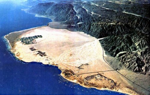 From their previous camping site (on the edge of the region called Etham) they turned south and entered a wadi (Wadi Watir) that must have seemed like an endless maze to them, with rugged mountains on their left and on their right.
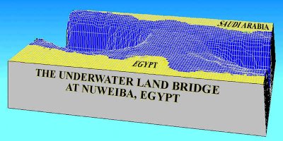 The physical requirements of the crossing site. You can't be in a place and complain that you left it. Proof positive that Israel was NOT IN EGYPT before they crossed. No Tomb for Pharaoh Pharaoh Koncharis and his entire army drowned; not one man lived to tell about it (Ps.106:11 "And the waters covered their adversaries; Not one of them was left"; 136:15a "But He overthrew Pharaohand his army in the Red Sea"). What's Down There Physical evidence on the floor of the Red Sea has been reported!!!
 Then they found chariot remains covered with coral.
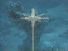 They found chariot cabs, some with the wheels on their axles and some off.
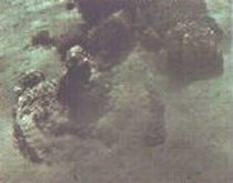 They found several 6-spoked wheels, as well as an 8-spoked wheel. He reports finding skeletal remains (hip bone, skulls, even a horse's hoof). None of the above works if there is no evidence on the other side.
Problems with the traditional site.
http://www.versebyverse.org/doctrine/redsea.html [This message has been edited by gmoore44 (edited 09-10-2006).] |
|
alabamahebrew Posts: 3 |
For $8.10 anyone can have the DVD of "The Exodus Revealed" which shows beyond a shadow of a doubt exactly where the true exodus took place and as Gmoore has shown it is indeed in Saudi Arabia and the pathe was where GMoore has shown. Order the DVD for yourself and see - deepdiscountdvd.com Thats the web site - the $8.10 includes the shipping! It is truly amazing when we can actually see where this magnificent event took place, it is truly inspirational! ------------------ |
|
scooter11 Posts: 130 |
I dont think even the land of Goshen is in the correct place. Its more likely close to this site...Lake Moeris. It was formed by a canal running off the Nile River called to this day the Canal of Joseph. Its near the center of Egypt and has a huge building used in his time to hold grain and so forth. But I agree with what has been posted, The Israelites crossed the red sea, not the sea of reeds, and the true mount is in Saudi Arabia. |


All times are ET (US) | next newest topic | next oldest topic |
  |
|
Contact Us | EliYah's Home Page
Please read the disclaimer. If you see any violations of forum guidelines, please contact the moderator.
Powered by Infopop www.infopop.com © 2000
Ultimate Bulletin Board 5.47e